Once a year I try to write an article about the history of our area, the Western Plains, Point Cook and Sanctuary Lakes. Last year while researching I found a drawing by the original architect, Chris Honey, which was the very first sketch of Sanctuary Lakes Resort, its lake, its golf course, houses and property.
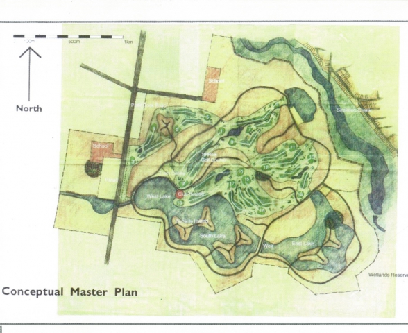
As you can see everything is outlined within the sketch; the lake and its butterfly islands, the entrance, the circuit of the boulevards and the shape of the golf course.
I have always been fascinated by the moment when an idea leaps out of the creator’s mind and becomes visual or audible so that it can, for the first time, be communicated.
It is the singularity before the big bang.
It is the moment that a concept becomes a reality.
It can now be seen.
It can now be discussed.
Working with Chris Honey was the original Sanctuary Lakes engineer and now SLC Vet golfer, David Hunter. Fortunately, we met playing a round and discussed how he and Chris, standing on a bare moon-scaped setting of basalt rock salt pans and decaying wooden pumps, conceived that this was the ideal location for an up-market residential development attached to an International Golf Course and Melbourne’s largest lake.
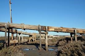
The landscape that David and Chris sourced their inspiration of Sanctuary Lake
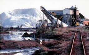
Aerial view of Cheetham multitudes of salt pans covering what is now Sanctuary Lakes
After a couple of months in the maturing pit of my mind, I sent David a letter outlining my thoughts and the basis of an article based on the Chris Honey Sketch
Hi David
Here are my initial questions based on viewing Chris Honey’s first concept drawing of Sanctuary Lakes.
What I would like to know and write about is, what were the ‘gravitational waves’ that pushed the idea?
- What were Developer Michael Tan’s riding instructions?
- What was the reality of the landscape you were going to build upon?
- Was it really a moonscape, were there trees, bushes hedges? Or simply basalt rock salt pans.
- Why a lake and what inspired it?
- Why the Butterfly shaped islands?
- Why the position of the Entrance? Did it already have the impressive Red River Gums growing?
- What were your thoughts when you first saw the location?
- What did you think when you first saw Chris Honey’s water colour sketch plan? Was it a Eureka moment or was it a vision of almost impossible mountain to climb or both?
I am sure your answers will create more questions but at least it is a start. Hopefully we can have a quick chat this Monday at the Vets check in and arrange a meeting for a discussion
Thanks for your help
Best wishes
Tom
His wonderful reply (below) was way beyond my expectations. It tells a gripping story of how the Sanctuary Lakes concept happened in a manner that only a person totally involved could tell:
Subject: The singularity
Good morning Tom,
Thank you for the opportunity to put down my memories of the process. I had been involved with the land well before it was purchased by Michael Tan. I was working for IEL at the time and negotiated the agreements for transfer of the wetlands to the State and the conditions of that transfer. I also worked with the planners to get the site rezoned for residential use. I knew the site intimately and the issues involved with getting it to a marketable state.
In the beginning ……
When the property was being re-zoned by IEL and put up for sale, we prepared what is called a yield plan, which sets out the highest and best use for the land - being residential - and the number of lots that one could expect to get from the parcel. That basically sets the land value. At that stage the expectation would have been 10 to 12 lots per hectare. However, the nature of the site meant that there would be less developable area because of the low-lying land and the requirement to fill it to make it viable for housing. The numbers we did at that stage indicated that the filling would have to be provided for free, if it was all to be developed. Bear in mind that the approach from developers at that stage was that Werribee was “first home buyer” and low cost was the aim.
So the initial plan, prepared in haste and with yield in mind, was for about 6,000 lots, with a water body in the middle. That plan was neither imaginative nor aesthetic. Its primary purpose was to get the value as high as possible. It was an exercise in value setting, not design.
So, when it went to market, there were two options:
- a) Avoid too much fill and create a bit of a water body, or
- b) Fill the lot over many years with free fill.
Michael Tan was made aware of the sale. He was interested in securing a parcel of land that was able to meet his expectations for a quality development. I was asked to pick him up from the city on a Wednesday morning to take him out to show him the land. The Agent, Frank Nagle, had emphasised that the site "was only 15 minutes from the city”. So, the drive out was quick, but achieved the timing objective.
The site in its original form, consisted of a large red brick building and out buildings which were now derelict, dirt roads, remnant salt patches and hectares of evaporation ponds and concentrators. These were a pink colour and caught Michael’s imagination about creating a "pink lake”. After explaining that the salt concentration was 10 times higher than sea water in order to get that colour, it was agreed that we wouldn’t go down that path.
We drove across the site over the next hour or so and ended up at the Skeleton Creek weir. The water body above the weir was bathed in sunlight and water birds. The city skyline beckoned in the distance, with the bay stretching out toward Dromana. The vista was all a sales team could need. Michael turned to me and said, "can you make this happen on that land? Can you make that look like this?” I hesitated, thought for a moment and said, “it’s possible Michael, but it will cost more to do.”
He thought about that for a while and looked out over Skeleton Creek, turned to me and Frank and said, "I think we can make this work.”
We travelled back to the city, within the 15-minute time frame, and made arrangements to meet again that evening to discuss the land.
Over the next few days, Michael asked for some more options on development plans, market advice on sales price and likely planning approval processes. I expect that he was also in discussion with Chris Honey, his architect in Kuala Lumpur and the UK. Chris was a one-man practice who split his time between Cambridge and Kuala Lumpur. He had designed a building for Michael and also a subdivision - urban design.
In the resulting discussions, the concept of a golf course and lake was put forward. I arranged for a rough sketch to be prepared and overall land use assessed to determine how many lots might be achieved from the site. In that process, Michael asked me to approach [then known as] Werribee Council about the likely support or otherwise for the broad concept proposed. I met with John Nicol, the then City Engineer, responsible for planning and development. I remember John’s words after I had finished my presentation. “This is exactly what the west needs, somewhere for the business owners to live. This is excellent.”
With that enthusiasm, Michael entered a contract of sale to secure the land. It’s fair to say, that there were not a lot of bidders for the site. The perception of problems with salt and fill had depreciated the value in the eyes of the local developers. All they could see was a “first home buyer market.” Michael could see much more… the Skeleton Creek aesthetic.
It was some time later that Michael returned to Melbourne, accompanied by an entourage of friends and investors and Chris Honey. We spent the next week taking people to the site, explaining how it might work, walking the site and thinking about how the site might integrate with the rest of Point Cook. At this point, the discussion about the golf course got serious. A number of designers were discussed. It’s important to also understand the protocol around the professional golf course designer process. Designers want to have a quality course which can have a high profile and enhance their brand. Developers don't want multiple “branded” courses in close proximity as it degrades their advantage. So, the selection of a designer has to take into account what courses they already have in the region, what they can bring to the project in terms of cachet and market value, and what can be leveraged for marketing.
The decision was taken to appoint Greg Norman as the designer as he did not have a course in the region, could bring all of the market value that the project needed and was fascinated with the prospect of changing the landscape at Point Cook. I was asked to pick up Greg and his Designer, Bob Harrison, from Essendon and take them to Point Cook to the first press day. This was the first time that Greg and Bob had seen the site. The press was there in force. After a series of presentations and questions and answers, Greg asked to be taken over the site.
Once in the middle of the site, we stopped to walk around. What attracted Greg’s eye was the salt bush and plants. The colours were deep green, purple and red. “Can we get these on the course?” he asked. “Absolutely", was my reply. We spent a few hours walking the site and discussing how the course might be set out, what were the implications for fill and top soil, how about water? These are the questions that can only be answered when a design is begun based on survey and geotechnical advice. The design process therefore had to be tempered until we had more information.
I set out getting the technical information and once available, we could start the process. With Greg (Bob Harrison) as the golf course designer, Chris Honey arrived to work on the project from our office for a few weeks. Bob Harrison came down from Sydney and we began the design process.
The base plan was put on the table, the original plan was reviewed and discarded. Yellow trace appeared and lines began to be appear highlighting the “must keep” elements. These included the copse of trees which is now the entry, the Skeleton Creek interface, the drainage lines required to meet the expectations of Melbourne Water and the “heritage items” which included the pump station blocks (which were concrete foundations) and the timber sluices. (After much discussion with Heritage Victoria, it was agreed that we could demolish these items after photographically recording them and maintaining an historic record of what the site was about).
As the design progressed, the course started to coalesce. The lake was still not resolved as the issues of filling and geotechnical conditions was still to be finalised. By this stage, we had cut channels through the lower areas of the salt pans to drain the area in preparation for survey. The drained areas revealed rock at shallow depth with the occasional dip in the profile. This encouraged me to confirm that islands are possible with special compaction processes.
With that information, Chris started to work on the detail of the urban design. The parameters were; a) there is a minimum surface area of lake required to meet flood management objectives; b) there is a minimum cross-sectional area of water way required to avoid any back up of water during a flood event.
The yellow trace came out and Chris went into his very intense state, drawing; overlay another sheet; draw some more, this time more strongly. Throw that away, more yellow trace, drawing, overlay more yellow trace, drawing with a thicker pen, another overlay, more drawings this time in a different colour. Question, “David, how would you build a bridge to the island?” “With box culverts, Chris.” “Right, but that’s going to look a bit industrial”. “Yep, might need to look at alternatives, but a full span bridge will be very expensive”. “Right.”
It’s around 7.30 pm. More yellow trace, this time the pen flows in a more fluid way. The pizza and beer are starting to get us all a bit freer. Bob has just about got the course sorted. We review where he’s at. It looks OK, but we need more lots. A bit of animated discussion ensues about the relative priority of golf and housing. We come to a compromise and decide to call it quits at 8.30 pm.
Next day, 7.30 am. Back at the table. Chris looks a bit shattered, but also a bit elated. He has been thinking.
Out comes the yellow trace and the black felt tip. The lake and course intersect now at a few points, following the review last night. “Here’s what we can do” says Chris. The pen moves over the yellow trace and the base plan. The edge of the lake starts to bend, and the first of the butterfly island shapes start to appear. Size is the issue - we need a minimum width to get house, road and services. The blocks need to be big to attract the price required. The waterway area is still critical. More trace, broad pen becomes finer as we put on dimensions. The islands appear in the right places, the land to the south gets narrower because the islands are the best result. We can get lots down each side of a road, but we need more land to make the islands work. The islands are where the money is. Let's buy the land to the south. That's the solution.
The plan evolves quickly now. The course is about set, the lake and islands are now the right size. What’s the reason for the shapes Chris? A basic design principle is to provide “long and short views”. He opened a small text called “A Pattern Language; C Alexander, S Ishikawa & M Silverstein”.
This is what he was reading last night and a re-read clarified for Chris that vision for the islands and how the lake will be viewed from the lots, the course, the entry road and the Club House. The landscape is enhanced and the community enriched.
The eastern part of the lake is not big enough to get the butterfly to work, but the principle is the same. Short and long views to emphasise space and context.
The shapes are looking good. "Now about the bridges - box culverts you say? Hmmm …. how about we put panels on the fronts so that they look “bridge like”?” This time its sketching, a box or two, just enough to separate the island from the land and then separate the two halves of the island. We need to maintain the waterway area, so the dimensioning is checked and double checked.
"How to fix a face panel to the boxes?"
"We hang it off the deck we cast on top of the boxes - simple as” I say, wondering how exactly we can do that. But I have designed and built bridges before, so it’s all doable.
The final touch is to dimension everything and then give it to the surveyors to prepare the plan, before the final approval. Chris heads back to Kuala Lumpur and then the UK. Bob is back in Sydney setting up the course design in detail, including the contouring to take advantage of the view lines created by the lake and the islands.
The layouts are complete, with lot dimensions, curve radius, existing trees and new contours. The view lines are checked and the plans tweaked. Everybody agrees that it works. Now to build what some believe to be impracticable.
The salt pans were created by pushing the topsoil into berms to hold the water. This topsoil is tested and found to be high quality, with very little salt content. Scrappers are set to work to strip the banks and stock pile for use on the golf course. The rest of the site is tested for salt content. Although high in some areas, it can all be managed by applying gypsum to the surface and allowing the rain to flush the salt through. The existing trees on the site are testament to the fact that landscape will not be affected by salt levels.
The land to the south was purchased and part used for filling for the project, as well as enhancing the lake outcomes and drainage control. Nearly 1 million cubic metres of filling was moved across the site during construction.
All filling is compacted under the supervision of a geotechnical engineer and tested every 600 mm of fill. The housing will be constructed on solid foundations. As with the road network. Some Council engineers were sceptical at first and insisted on additional strength testing on all sites. An expectation of salt contamination was unfounded and after much debate, there was agreement that the project was viable. From then on, the community began to see the potential. Deposits for house lots were opened and within 24 hours the first stage was gone.
The lake was originally constructed in two parts to ensure that the water levels would be maintained and the drainage controls achieved. This also enabled construction of the remaining islands to be undertaken.
The project required considerable investment and vision. Michael Tan’s preparedness to think differently to the local developers and see the potential is a testament to his courage and conviction. Being able to share that vision and bring it to reality has been one of the highlights of my career.
I hope this helps to explain how it came to be.
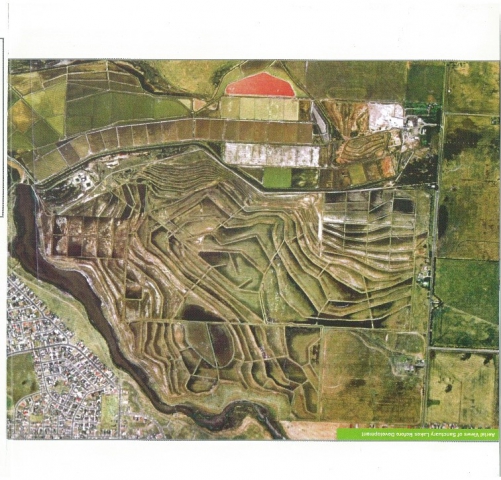
And 22 years later, it became a reality
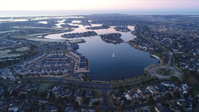
Sanctuary Lakes 2018 photo by Terry